


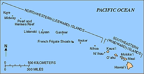
Northwestern Hawaiian Islands
The Northwestern Hawaiian Islands - Leeward Islands
When most people think of Hawaii, they think about Honolulu, Waikiki Beach and Pearl Harbor (which are all on the island of Oahu); others are maybe even familiar with the neighbor islands of Kauai, Maui, Lanai, Molokai or the Big Island, the lesser visited Hawaii tourism destinations. But who has ever heard of Nihoa, Laysan, Necker, Lisianski, French Frigate Shoals, Kure Atoll or the Gardner Pinnacles? These and many other small islands, reefs, shoals and atolls are called the Northwestern Hawaiian Islands, or the Leeward Islands.
Spanning more than 1,200 miles (1,931 km) in the Pacific Ocean, all of them are uninhabited, little known and rarely visited (except for a few researchers who do their work there). If you were to lay these islands atop the continental United States, they would cover a distance from Boston, Massachusetts, to the Florida Everglades. The Northwestern Hawaiian Islands encompass a land area of 3,100 square miles (8.030 km²).
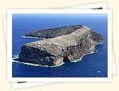
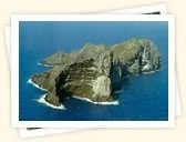
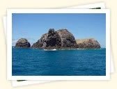
The largest of the islands are: Nihoa, Necker (Mokumanamana), French Frigate Shoals (Mokupapapa), Gardner Pinnacles (Puhahonu), Maro Reef (Nalukakala), Laysan (Kauo), Lisianski (Papaapoho), Pearl and Hermes Atoll (Holoikauaua), Midway (Pihemanu) and Kure (Kanemilohai). The Midway Islands are part of the Hawaiian archipelago, but are not legally part of the state of Hawaii. While most of the abovementioned islands are administered by the state of Hawaii, Midway is administered by the U.S. Fish and Wildlife Service and has temporary residential facilities.

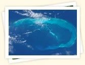
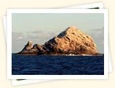
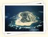
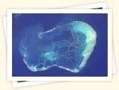
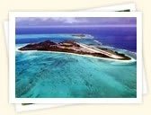
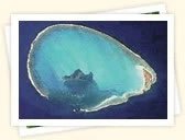
All of the Northwestern Hawaiian Islands were formed over the same volcanic hotspot that formed the eight Main Hawaiian Islands (Kauai, Niihau, Oahu, Maui, Molokai, Lanai, Kahoolawe and the Big Island) to the south. As time went by, the islands gradually eroded and subsided, evolving from high islands (in the south) to atolls or seamounts (in the north). Each one of the islands is in a different stage of erosion. Because the northwesternmost islands are the oldest, they have eroded the most. Necker, Nihoa and the Gardner Pinnacles are rocky basalt islands that haven't eroded enough to form an atoll, while Laysan and Lisianski are low, sandy islands that have eroded longer. The French Frigate Shoals, Pearl and Hermes, Midway and Kure are all atolls. As the Pacific Plate moves northwest, the islands become seamounts and will eventually sink beneath the ocean. Kure Atoll will be the first.
Because of the isolation of the Northwestern Hawaiian Islands (they are about 2,500 miles from North America and 3,800 miles from Asia), they are home to a large number of endemic or unique species. While the ecosystem of the Main Hawaiian Islands has changed over the years (mainly because humans introduced foreign species), the ecosystem in the Northwestern Hawaiian Islands remains largely intact. More than 1,700 species in the Northwestern Hawaiian Islands are endemic, which means that they can't be found anywhere else in the world. That's why this region has also been called "America's Galapagos."


In the late 1800s to the early 1900s, the Northwestern Hawaiian Islands experienced abuse when fishermen, feather hunters and guano miners killed most of the birds and sea life there. Also, rabbits were brought to Laysan and Lisianski where they multiplied and consumed all the vegetation, extinguishing several species forever. But luckily, the islands were later restored and are now almost in the same condition as they were before their exploitation.
Today's endemic species in the Northwestern Hawaiian Islands include the Laysan duck, the Laysan albatross, the Nihoa and Laysan finch, the Hawaiian monk seal and the Hawaiian green sea turtle. Seventy percent of all coral reefs in the United States are located here. These coral reefs are some of the healthiest and most undisturbed reefs in the world. More than 7,000 species, including fish, turtles, birds, marine mammals and invertebrates can be found here (about a quarter are endemic).
President George W. Bush issued a proclamation on June 15, 2006 that created the Papahanaumokuakea Marine National Monument under the Antiquities Act of 1906. The monument encompasses the Northwestern Hawaiian Islands and surrounding waters and is the largest marine wildlife reserve in the world. It is about the size of the U.S. state of California, 139,000 square miles (360,000 km²).
A strict permit system is in place that must be followed by anyone who wishes to come here. This is to prevent any stray species from entering and disrupting the ecosystem. The permit system is administered by the state of Hawaii, NOAA and FWS. All clothes must be new and one must keep them wrapped just before arrival. "Soft" items like blankets or camera straps must also be new, and all "hard" items like cameras or binoculars must be thoroughly cleaned and frozen for 48 hours. To prevent inter-island species introduction, one must prepare a new set of equipment for each island one is going to. This rule applies for all islands, except for the French Frigate Shoals and Midway Atoll because they are already too altered by humans.
Courtesy of United States Department of Interior
Northwestern Hawaiian Islands
Below is an overview of the Northwestern Hawaiian Islands, listed in geographical order from the southwest to the northeast. Kaula Island is not part of the Northwestern Hawaiian Islands (the geographical border begins at Nihoa Island to the northeast of Kauai). But we listed Kaula Island (which is located to the southwest of Niihau) here anyway because we thought it's an interesting little rock that not many people know about.