
Islands in the Central Pacific
Hawaii Geography
Hawaii's geography spans volcanic islands, coral atolls, high mountains, deep valleys, long coastlines and one of the most remote island chains on Earth.
Hawaii's Place in the Pacific
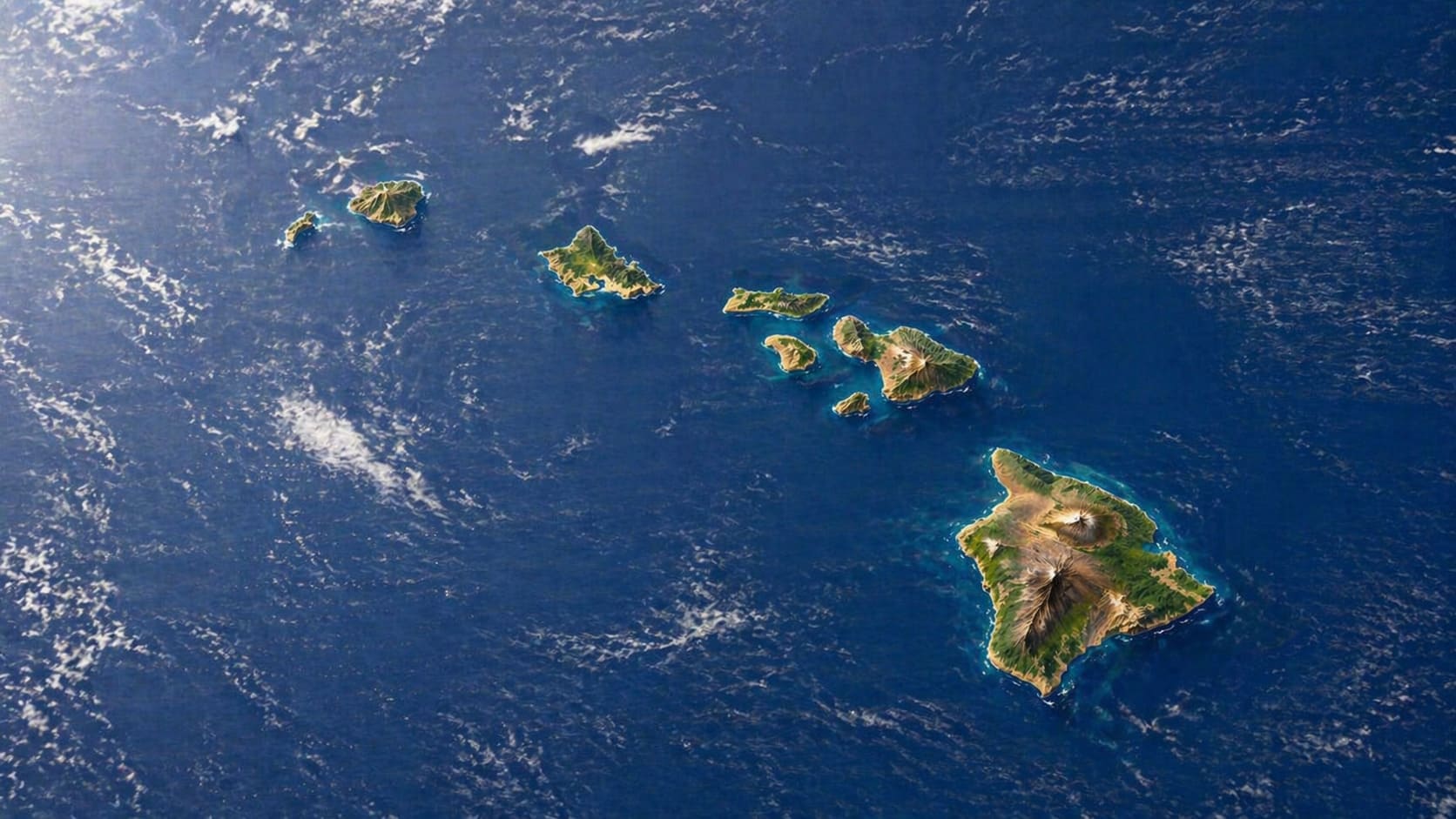
Hawaii geography is unlike any other U.S. state. The Hawaiian Islands sit in the Central Pacific Ocean, thousands of miles from the nearest continental landmass, and form the exposed peaks of massive volcanic mountains rising from the seafloor.
The island chain stretches far beyond the eight main Hawaiian Islands most visitors know. It continues northwest through remote reefs, shoals, atolls and low islands that make up the Northwestern Hawaiian Islands.


Hawaii – One of the World's Most Remote Island Chains
Hawaii is one of the most isolated populated island chains on Earth. The Islands sit about 2,390 miles from California and about 3,850 miles from Japan.
Because of this remote location, Hawaii developed unique ecosystems, rare native species and a strong island identity. At the same time, that isolation affects shipping, food costs, travel time and daily life for residents.
The Hawaiian Archipelago
The Hawaiian archipelago stretches about 1,523 miles from the Big Island in the southeast to Kure Atoll in the northwest. This long chain includes the main Hawaiian Islands, plus many smaller islands, reefs and atolls.
The eight main Hawaiian Islands are Hawaii Island, Maui, Oahu, Kauai, Molokai, Lanai, Niihau and Kahoolawe. These islands sit at the southeastern end of the chain, where the youngest and largest islands are located.
The Northwestern Hawaiian Islands
Northwest of the main islands, the chain continues through the Northwestern Hawaiian Islands. These remote islands, reefs and atolls include places such as Nihoa, French Frigate Shoals, Laysan Island, Pearl and Hermes Atoll, Midway Atoll and Kure Atoll.
Most of these areas have no permanent residents, but they support seabirds, monk seals, sea turtles, coral reefs and important marine ecosystems. Much of this region lies within Papahanaumokuakea Marine National Monument.
How the Hawaiian Islands Formed
Volcanic activity formed all of the Hawaiian Islands. As the Pacific Plate moved over a hot spot beneath the ocean floor, magma rose and built underwater volcanoes layer by layer.
Eventually, some of these volcanoes grew tall enough to rise above sea level. As the plate continued moving northwest, older volcanoes drifted away from the hot spot, while new volcanic activity continued near the southeast end of the chain. You can learn more in the Hawaii volcanoes guide.
Young Islands and Old Islands
The islands grow older as you move northwest through the chain. The Big Island is the youngest of the main Hawaiian Islands, and its volcanoes remain the most active.
By contrast, Kauai and Niihau are much older and more deeply eroded. Farther northwest, older islands have worn down into low islands, reefs and atolls.
Volcanoes and New Land
Hawaii's volcanic story continues today. Kilauea and Mauna Loa on the Big Island have produced modern eruptions, and lava flows can add new land when they reach the ocean.
However, visible lava is never guaranteed. Volcanic activity changes often, and visitors should always check current conditions before planning around lava viewing. Hawaii Volcanoes National Park is the best place to learn about the Big Island's active volcanic landscape, while the Hawaiian lava guide explains how lava shapes the Islands.
Hawaii's Main Islands by Size
The Big Island is by far the largest Hawaiian island. In fact, it is larger than all the other main Hawaiian Islands combined.
- Hawaii Island: 4,028.42 square miles (10,433.55 km²)
- Maui: 771.99 square miles (1,999.45 km²)
- Oahu: 597.64 square miles (1,547.88 km²)
- Kauai: 552.35 square miles (1,430.59 km²)
- Molokai: 260.46 square miles (674.58 km²)
- Lanai: 141.07 square miles (365.36 km²)
- Niihau: 67.60 square miles (175.09 km²)
- Kahoolawe: 44.60 square miles (115.50 km²)
Comparing the Islands by Size
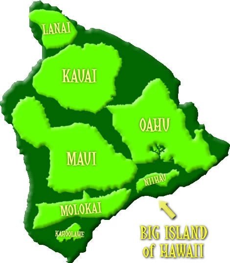
This graphic shows how large the Big Island is compared with the other main Hawaiian Islands. The land areas of Maui, Oahu, Kauai, Molokai, Lanai, Niihau and Kahoolawe all fit within the Big Island's land area, with room left over.
The map is approximate and not to scale, but it gives a helpful visual sense of how the islands compare. For visitors planning a trip, the size difference also explains why driving distances feel very different from island to island. The Big Island has long drives between resort areas, volcano landscapes and coastal towns, while smaller islands such as Lanai or Molokai feel more compact and rural.
Island size also affects population, road systems, weather patterns and the amount of land available for towns, farms, parks and conservation areas. Although Oahu is much smaller than the Big Island, it has the largest population and the state capital. Meanwhile, the Big Island has the most land area, the tallest mountains and the greatest range of climate zones.
Hawaii's Land Area and Coastline
Hawaii's total land area is about 6,422.63 square miles. Although the Islands cover a relatively small land area compared with many states, the archipelago spans a vast distance across the Pacific.
Hawaii has about 750 miles of coastline. Beaches, sea cliffs, lava shelves, coral reefs and coastal plains all contribute to the state's varied shoreline. Visitors can explore this variety through guides to Hawaii beaches, beach sand composition and the Hawaii underwater world.
Hawaii's Mountains
The highest mountains in Hawaii are on the Big Island. Mauna Kea rises 13,796 feet above sea level, while Mauna Loa rises 13,679 feet above sea level.
Measured from its base on the ocean floor, Mauna Kea is taller than Mount Everest. Its summit is also one of the world's most important astronomy locations, although it remains culturally and environmentally sensitive.
Elevations of Major Hawaii Summits
| Island / Summit | Elevation in Feet | Elevation in Meters |
|---|---|---|
| Hawaii Island – Mauna Kea | 13,796 feet | 4,205 meters |
| Hawaii Island – Mauna Loa | 13,679 feet | 4,169 meters |
| Hawaii Island – Hualalai | 8,271 feet | 2,521 meters |
| Hawaii Island – Kohala | 5,480 feet | 1,670 meters |
| Hawaii Island – Kilauea | 4,093 feet | 1,248 meters |
| Maui – Haleakala | 10,023 feet | 3,055 meters |
| Maui – Pu'u Kukui | 5,788 feet | 1,764 meters |
| Maui – Iao Needle | 2,250 feet | 686 meters |
| Oahu – Kaala | 4,003 feet | 1,220 meters |
| Oahu – Pu'u Kalena | 3,504 feet | 1,068 meters |
| Oahu – Konahuanui | 3,150 feet | 960 meters |
| Oahu – Diamond Head | 760 feet | 232 meters |
| Kauai – Kawaikini | 5,243 feet | 1,598 meters |
| Kauai – Waialeale | 5,148 feet | 1,569 meters |
| Kauai – Kalalau Lookout | 4,120 feet | 1,256 meters |
| Molokai – Kamakou | 4,961 feet | 1,512 meters |
| Molokai – Olokui | 4,606 feet | 1,404 meters |
| Lanai – Lanaihale | 3,366 feet | 1,026 meters |
| Niihau – Paniau | 1,250 feet | 381 meters |
| Kahoolawe – Pu'u Moaulanui | 1,483 feet | 452 meters |
Elevations are commonly cited reference values and may vary slightly by source, measurement point or spelling style.
Rivers, Streams and Waterfalls
Hawaii does not have many long rivers because the Islands are small, steep and volcanic. However, the Islands have many streams, waterfalls and wet valleys, especially on windward mountain slopes.
Kaukonahua Stream on Oahu is often cited as one of Hawaii's longest streams. Molokai's north shore is known for towering sea cliffs and high waterfalls, while Kauai and Maui also have dramatic cascades in wet mountain regions. Visitors can learn more in the Hawaii waterfalls guide.
Windward and Leeward Geography
Hawaii's mountains strongly affect rainfall and climate. Windward sides face the trade winds and tend to be wetter, greener and more lush.
Leeward sides sit in the rain shadow of the mountains. As a result, they are usually drier, sunnier and more common for resort areas, beaches and dry coastal landscapes. This windward-leeward pattern is one of the most important parts of Hawaii climate.
Hawaii's Geographic Coordinates
Honolulu is located near 21°18′ north latitude and 157°51′ west longitude. The state as a whole spans a much larger area because the island chain stretches far northwest across the Pacific.
This broad geographic spread helps explain why Hawaii includes tropical beaches, high volcanic summits, coral atolls, dry lava plains and wet mountain forests within one state.
Why Hawaii's Geography Matters
Hawaii's geography shapes nearly every part of island life. Volcanic mountains influence rainfall, roads, farming, settlement patterns and natural hazards. Remote location affects travel, shipping, food costs and conservation.
Meanwhile, the Islands' isolation helped native plants, birds, insects and marine life evolve in remarkable ways. Many species found in Hawaii flora and Hawaii fauna live nowhere else on Earth.
Planning Around Hawaii Geography
Understanding Hawaii geography can make trip planning easier. A short drive on one island may cross dry coastlines, wet valleys and cooler uplands, while another island may require much longer travel between resort areas, beaches and mountain attractions.
If you want help seeing major landmarks without planning every route yourself, compare Hawaii island tours. Guided tours can be especially useful for visitors who want to see scenic lookouts, volcano areas, waterfalls, historic places and coastal viewpoints in one day.
Hawaii's Living Landscape
Hawaii's landscape continues to change. Lava can create new land, waves can reshape coastlines, rain can carve valleys and coral reefs can grow around older islands.
Because of this constant change, Hawaii's geography is not just a static map. It is a living story of volcanoes, ocean, wind, rain and time.
Frequently Asked Questions
Where is Hawaii located?
Hawaii is located in the Central Pacific Ocean, about 2,390 miles from California and about 3,850 miles from Japan.
How were the Hawaiian Islands formed?
The Hawaiian Islands formed through volcanic activity as the Pacific Plate moved over a hot spot beneath the ocean floor.
How many main Hawaiian Islands are there?
There are eight main Hawaiian Islands: Hawaii Island, Maui, Oahu, Kauai, Molokai, Lanai, Niihau and Kahoolawe.
Which Hawaiian island is the largest?
The Big Island of Hawaii is the largest island. It is bigger than all the other main Hawaiian Islands combined.
What is the highest point in Hawaii?
Mauna Kea on the Big Island is the highest point in Hawaii at about 13,796 feet above sea level.