


Kiholo Bay
Kiholo Bay is a scenic coastal area on the Big Island's Kohala Coast, offering a unique blend of history, marine life, and striking lava rock landscapes. Its calm lagoon invites swimmers and snorkelers, while tide pools, ancient fishponds, and sea turtles enhance its natural and cultural appeal. Though remote and without facilities, Kiholo Bay rewards the effort to reach it with tranquility and breathtaking views of land and sea.
Kiholo Bay, Big Island
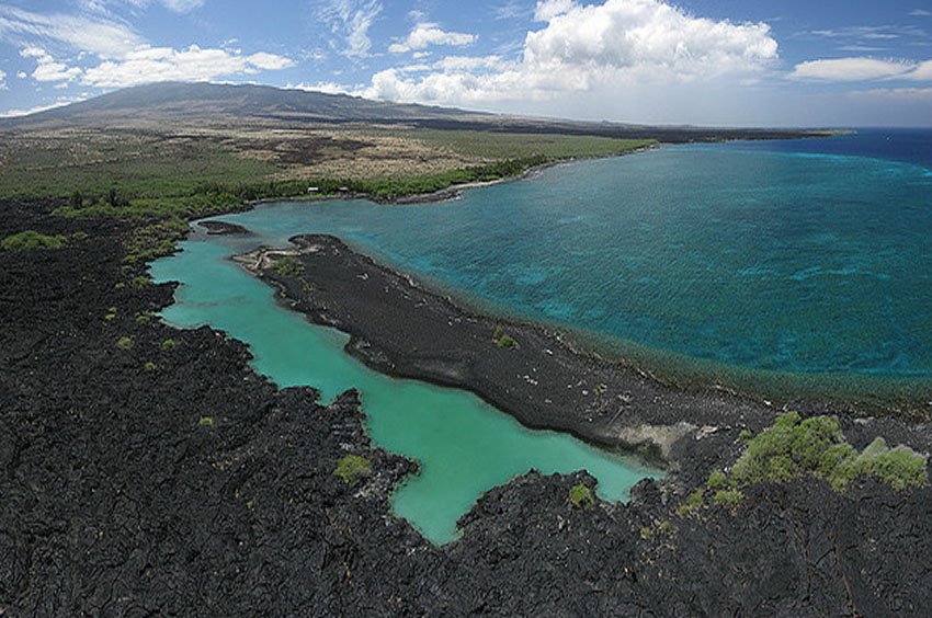
If you were to squeeze the Big Island into a single beach, you'll end up with something like Kiholo Bay (view panorama) × . This Kohala Coast beach has a little of everything: beautiful sights, fascinating wildlife, tide pools, ancient ponds and rock formations. There's even a mini-island made of lava rock right at the heart of the bay.
The bay itself consists of a mix of fresh and salt water, surrounded by dark lava rocks and a usually calm lagoon. The lagoon is a great spot for swimming and snorkeling, since the water in it is usually calm compared to the rest of the bay.
Much of the bay was once a Hawaiian fishpond built in 1820 by King Kamehameha I. Its boundaries were 2 miles (3.2 km) long and its rock walls were 6 feet (1.8 m) tall and 20 feet (6 m) wide. In 1859, a lava flow from the Mauna Loa volcano, located 30 miles (48 km) away from here, reached Kiholo Bay and destroyed the southern portion of the ancient fishpond and created the lagoon you see today.
At the northern end of the bay is Wainanali'i Pond, which is connected to the ocean via a man-made channel. It is an important feeding and sleeping site for green sea turtles. However, it is located on private property and therefore not accessible. Bordering Kiholo Bay to the south is Luahinewai Pond, a freshwater pool that's surrounded by coconut palms and lush vegetation. This area is also on private property and off-limits to visitors.
On your way to Kiholo Bay, stop at Mile Marker #82 on Highway 19 at the Kiholo Bay Scenic Overlook, from where you can see most of the bay and its sprawling coastline (see below for directions on how to access the bay).
Key Features of Kiholo Bay
- Natural lagoon: Calm waters ideal for swimming and snorkeling, fed by freshwater springs and ocean tides.
- Green sea turtles: Frequent visitors to the bay, often seen feeding or resting along the shore.
- Historic fishpond: Built by King Kamehameha I in 1820 and partially destroyed by lava in 1859.
- Remote and undeveloped: No public restrooms or lifeguards; visitors must bring their own supplies.
- Scenic overlook: Panoramic views from Mile Marker 82 along Highway 19 before hiking or driving down.
- Location: Kohala Coast, between Mile Markers 82 and 83 on Highway 19, north of Kailua-Kona


Frequently Asked Questions
Where is Kiholo Bay located?
Kiholo Bay is located on the Big Island's Kohala Coast, about 19 miles north of Kailua-Kona. Access is via a gravel road near Mile Marker 82 on Highway 19.
Can you swim at Kiholo Bay?
Yes, the lagoon within the bay usually offers calm water ideal for swimming. However, conditions can vary, so use caution.
Are there sea turtles at Kiholo Bay?
Yes, green sea turtles often feed on seaweed (limu) in the bay and may be seen resting along the shore. Please observe from a distance.
What is the historical significance of the bay?
Kiholo Bay was once home to a large fishpond built by King Kamehameha I in 1820. It was partially destroyed by a Mauna Loa lava flow in 1859.
Are there any facilities or restrooms?
No. Kiholo Bay is a remote natural area without public facilities, restrooms, or lifeguards. Bring your own supplies and pack out trash.