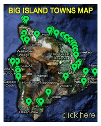
Big Island Towns
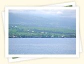
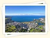
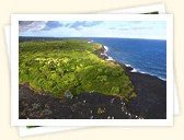
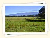
 The Big Island of Hawaii has two main residential areas – Hilo and Kailua-Kona. Hilo is the county seat and the only major city on the island's windward coast. It is also the wettest city in the United States (no, it's really not Seattle as many people may believe). The town is surrounded by an abundance of tropical greenery, thanks to the rain.
Kailua-Kona, on the other hand, is on the dry side of the island – the hub of tourism. Small towns and villages are scattered throughout the rest of the island, which has a population of 185,079 (2010 Census). Even though the Big Island has the second largest island population in the state of Hawaii, its population density is among the lowest (after Molokai, Lanai and Niihau) because of its size.
FIND BY NAME:
A | B |
C | D | E | F | G |
H | I | J |
K |
L |
M |
N |
O |
P | Q | R | S | T | U |
V |
W | X | Y | Z
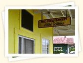
Captain Cook is the last of the “big” towns on the island's west shore south of Kailua-Kona and the gateway to attractions in this area. It has a few cozy B&Bs and small shops, including kayak rentals and a gas station.Read More
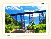
Hakalau, located on the Big Island's Hamakua Coast, was home to a large sugar plantation up until the early 1960s. Remnants of the village's prosperous past can still be seen in the old railroad bridge that leads to Hakalau Bay.Read More
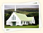
Hawi is the largest town on the Big Island's north shore and has several art galleries, shops, a few restaurants and a hotel. It was once a bustling sugar plantation town and today is known for its picturesque charm.Read More
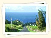
Situated on the rainy windward side of the Big Island, Hilo is the wettest city in the U.S. with an average rainfall of 128 inches (325 cm) annually. The city is the most tropical in Hawaii and lush greenery is a normal part of the landscape.Read More

Holualoa is a small coffee-farming village situated 1,400 feet (427 m) above Kailua-Kona. The town is primarily a single road called Mamalahoa Highway and along it are several fine-art galleries and coffee shops.Read More
Honaunau is a small community located at Honaunau Bay. The area is known for its national historical park, which was once a sanctuary for ancient lawbreakers. Another attraction in Honaunau is the St. Benedict's Painted Church. Read More
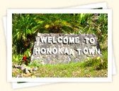
Honoka'a is the largest town on the Hamakua Coast (and once was the third largest in all of Hawaii, after Honolulu and Hilo) with a rich history due to the dozens of sugar plantations and cattle industry it had more than a hundred years ago. Read More
Honomu on the Big Island of Hawaii used to be a bustling sugar plantation town. Today, the main attraction in the area is the Akaka Falls State Park, a 422-foot (129 m) waterfall.Read More
Kailua-Kona, located along the shoreline of Kailua Bay on the west shore of the Big Island of Hawaii, enjoys a combination of sunny and dry weather all year round. This is where King Kamehameha the Great spent the last years of his life.Read More
Locally known as the "five-mile hill," Kainaliu is an old plantation town home to the Aloha Theatre, which opened in 1932 originally as a silent theater. It continually showcases film, live music and dance. Read More
Kalapana, located in the Big Island's Puna District, was once a thriving fishing village and considered one of the most beautiful Hawaiian villages. Today, Kalapana is one dark ocean of solidified lava. Read More
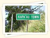
Located on the northern tip of the Big Island is the small historical village of Kapa'au. It is best known for being home to the statue of King Kamehameha the Great, who unified the Hawaiian islands under his rule. Read More
Kapoho was destroyed by a lava flow when Kilauea erupted in 1960. Today, the area is known for its unique bathing experience at the Kapoho Tide Pools, some of which are volcanically heated. Read More
Kawaihae is a small port town along the Big Island's northwestern Kohala Coast. The main attraction in this area is the Pu'ukohola Heiau, an ancient war temple built by King Kamehameha the Great. Read More
Kea'au is surrounded by an Ohia forest, and nearby are black-sand beaches and a plethora of botanical gardens. Two attractions are the 20-hectar greenhouse Pacific Floral Exchange and the Hi'iaka Healing Herb Garden. Read More
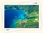
The historic town of Kealakekua is most famous for being the landing spot of Captain Cook, who sailed into Kealakekua Bay in January 1779 and was killed here a month later. The bay is surrounded by 600-foot (183 m) high sea cliffs. Read More
Located at an elevation of 620 feet (190 m), Kurtistown it is one of the most agriculturally productive communities on the Big Island. There are many banana plantations and flower gardens here. Read More
Laupahoehoe is a small village on the Hamakua Coast offering breathtaking ocean vistas – breaking waves, craggy lava rocks and lush vegetation. With this scenic beauty, one would never imagine that the town keeps one tragic past. Read More
True to its name, this town provides ample mountain views. In fact, one of the world's tallest mountains and volcanoes – Mauna Kea – looms next door. Mountain View is also home to many nurseries specializing in anthuriums. Read More
Located near South Point in the Big Island's Ka'u District, Na'alehu bills itself as the southernmost town in the United States. There are only a few small shops and eateries in this quaint little town. Read More
Ocean View is located in the Big Island's Ka'u district near South Point. Living here means living a rugged life amidst lava fields and few modern conveniences. People here are self-sufficient and live a life off the grid. Read More
O'okala is a small community of fewer than 200 people on the Big Island's lush Hamakua Coast, about 4 miles (6.4 km) north of Laupahoehoe. Read More
For those who really like to get off the beaten track, this tiny community is worth a visit. Though you won't find any tourist services or lodging to speak of, Pa'auhau does have an interesting history. Read More
Pa'auilo used to be a booming sugar town in the past. But when sugar production ceased in this area, the town's character changed. Today, it is a sleepy community with a few small neighborhoods, a grocery store and post office. Read More
This former sugar town is located in the Big Island's Ka'u District. Sugar was grown here up until the 1990s and the local townspeople believed that this would always be that way because “sugar is king.” However, the marketplace changed. Read More
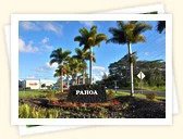
Pahoa is located in the Big Island's Puna District. The pride of Pahoa is its raised wooden sidewalk, the false-front stores and the numerous old buildings, which give it a "Wild West" atmosphere. Read More
The old village of Papa'aloa is located along the lush Hamakua Coast. Papa'aloa retains much of its old plantation feeling, and visiting the town reminds of yesteryear – a time that was filled with plantation camps and sugar mills. Read More
A natural paradise located just north of Hilo, Papa'ikou's main attraction is the nearby Hawaii Tropical Botanical Garden, a lush sanctuary sheltering over 2,000 species of rare tropical plant species from around the world. Read More
The biggest draw of the area around Pepe'ekeo is the four-mile (6.4 km) stretch of road between Papaikou and Pepe'ekeo (Old Mamalahoa Highway) that leads past the Hawaii Tropical Botanical Garden. Read More
Pukao's main attraction is its large collection of intricate petroglyphs carved into volcanic rocks. The coastline around Puako is known for its crystal clear, cobalt blue waters and top notch snorkeling and diving conditions. Read More
Volcano is located at the entrance to the Hawaii Volcanoes National Park. The village literally sits on the slopes of one of the most active volcanoes in the world – Kilauea. But the landscape is amazingly lush. Read More
Local residents often times call the town "Waiko-blow-a" because it is often times quite windy here. Two attractions in this area are the Waikoloa anchialine ponds and a petroglyph field featuring ancient rock carvings. Read More
Waimea is also known as Kamuela. The name is used to distinguish this Big Island town from Kauai and Oahu towns that are also named Waimea. It is located in the interior of the Big Island at an elevation of 2,670 feet (814 m). Read More
The small town of Wai'ohinu, which means "shiny water" in the Hawaiian language, is a small community located in the Ka'u district near South Point. Author Mark Twain visited Wai'ohinu in 1866 and planted a monkeypod tree here. Read More