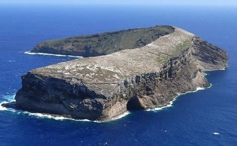
Ka'ula Island
Ka'ula Island is a small, uninhabited crescent-shaped islet southwest of Ni'ihau. Known for its dramatic cliffs, marine biodiversity, and ancient heiau sites, the island has been used by the U.S. Navy as a bombing range since the 1950s. Due to unexploded ordnance, landing is restricted, though nearby waters attract divers and fishermen.

Ka'ula is a small crescent-shaped islet, located about 23 miles (37 km) southwest of the island of Ni'ihau. The small island is uninhabited, and it is believed that no one ever lived here permanently, even though the island was known to the Native Hawaiians who visited it. Two stone structures have been found near the island's summit, which might have been heiaus (ancient temple sites). The highest point of the island is 548 feet (167 m) above sea level and the total land area is 158.2 acres (0.64 km²).
The island is slowly shrinking due to erosion. There is a large cave on the northwestern side of Ka'ula, which is known as Kahalauaola (Shark Cave). The former United States Lighthouse Service built a lighthouse on Ka'ula in 1932, which was in operation until 1947. The U.S. Navy has been using the island as a bombing target since 1952, and unexploded ordnance might still be found on the island. That's why one needs permission from the U.S. Navy to land on Ka'ula. The waters near Ka'ula are visited by fishermen and scuba divers.
Frequently Asked Questions
Where is Ka'ula Island located?
Ka'ula Island is located about 23 miles (37 km) southwest of Ni'ihau. It is the westernmost island in the Hawaiian chain, apart from the Northwestern Hawaiian Islands.
Can you land on Ka'ula Island?
No, landing is restricted due to unexploded ordnance from past military training. Permission from the U.S. Navy is required to access the island, though nearby waters are accessible for diving and fishing.
Was Ka'ula Island historically significant to Native Hawaiians?
Yes. Though uninhabited, the island was known to Native Hawaiians, and two stone structures near the summit are believed to be ancient heiau (temples), suggesting ceremonial use.
What is Shark Cave on Ka'ula Island?
Shark Cave, or Kahalauaola, is a large sea cave on the northwestern side of Ka'ula. It's a distinctive geological feature often referenced in oral traditions and visited by divers from nearby waters.
Is Ka'ula still used by the military?
The U.S. Navy has used Ka'ula Island as a target for bombing practice since 1952. Although it’s no longer in frequent use, remnants of past ordnance remain, which is why public access is restricted.


