


Manini Beach
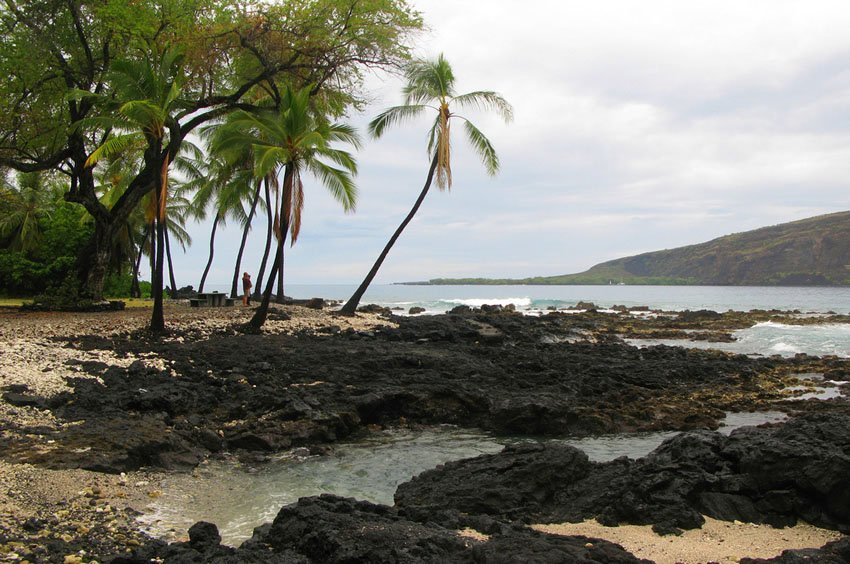
Manini Beach is a scenic coastal park on the Big Island's west shore, just south of Kealakekua Bay. Known for its rocky shoreline made of coral rubble and lava rock, the beach offers calm-water snorkeling, scenic views of the Captain Cook Monument, and grassy areas shaded by trees. While not ideal for swimming, it's a peaceful spot for relaxing, diving, and shoreline picnics, with local cultural significance and tsunami history.
Manini Beach, Big Island
Located on the Big Island's west shore just south of popular Kealakekua Bay, Manini Beach has a rocky shoreline consisting of white coral rubble and black lava rocks. The beach wraps around the north point of Kahauloa Bay, and the area behind it belongs to Napo'opo'o Park.
The surfing conditions are sometimes good here, especially if the waves break far enough out so that surfers can safely navigate away from the nearby rocks. Other water activities that are possible include snorkeling and scuba diving. There is a small sandy channel that cuts through the reef and allows for easy access into the ocean.
The best underwater visibility can be found to the right of the channel. During rough ocean conditions, it is best to stay out of the water because it can get quite turbulent and this is when underwater visibility is diminished as well.
For those who prefer to stay out of the water, Manini Beach offers nice views of the Kealakekua cliffs and the Captain Cook monument. The beach is a nice picnic spot as well and picnic tables are available. The park has grassy areas and trees that provide shade.
Manini Beach and the entire Napo'opo'o area were hit hard on March 11, 2011, when a tsunami (which was generated by the magnitude 9.0 earthquake in Japan) washed ashore here and caused extensive damage to many of the beach homes. One of the homes next to Manini Beach was lifted up and sucked out to sea.
Key Features of Manini Beach
- Rocky shoreline: Composed of coral rubble and black lava rock, with a small sandy entry channel for water access.
- Good snorkeling: Calm water and marine life make it suitable for snorkeling and scuba diving during gentle surf conditions.
- Surfing spot: Surf is possible when waves break farther out from the rocky shoreline.
- Scenic views: Excellent vantage point to see Kealakekua Bay and the Captain Cook Monument across the water.
- Tsunami history: Damaged in the 2011 tsunami, highlighting the area's vulnerability and resilience.


Frequently Asked Questions
Where is Manini Beach located?
Manini Beach is located just south of Kealakekua Bay in the town of Captain Cook, off Manini Road from State Highway 160.
Is Manini Beach good for snorkeling?
Yes, especially during calm conditions. The best visibility is to the right of the sandy entry channel.
Can you swim at Manini Beach?
Swimming is limited due to rocks and surge, but access is possible through a small sandy channel. Conditions vary with ocean swell.
Are there facilities at Manini Beach?
There are grassy areas, picnic tables, and shade, but no public restrooms or lifeguards on-site.
What views can I see from Manini Beach?
The beach offers a scenic perspective of Kealakekua Bay and the white obelisk marking the Captain Cook Monument.