


Hakalau Bay
Hakalau Bay is a scenic and historic cove on the Big Island's east coast, known for its lush rainforest surroundings, black-sand shoreline, and remnants of the island's sugar plantation era. While not ideal for swimming, it offers excellent photo opportunities and access to nearby forest reserves.
Hakalau Bay, Big Island
Located on the Big Island’s eastern shore, about 13 miles (21 km) north of Hilo, Hakalau Bay is mainly a place to go to take pictures rather than go swimming or snorkeling. The small bay has deep offshore waters and dangerous water conditions develop during times of high surf.
The ocean bottom drops off quickly here and rip currents often times run from the bay into the open ocean. However, the bay is sometimes used by surfers. At the head of the bay, Hakalau Stream flows into the ocean, so the inshore waters are always murky. The beach is composed of black sand and fine pebbles.
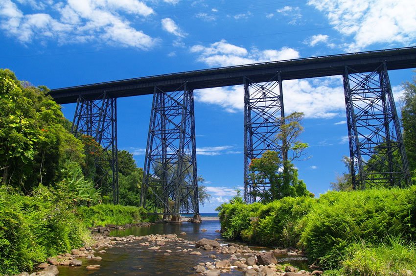
The town of Hakalau was once home to a thriving sugar industry and an important stop for local transport. Remnants of its prosperous past can still be seen in the old railroad bridge that leads to the bay and the long-defunct plantation towers you can see from the road. Also located on the shoreline are the ruins of Hakalau Mill, which was destroyed in the tsunami of 1946.
If you’d rather stay out of the water, you can check out the nearby Hakalau Forest National Wildlife Refuge. This 33,000-acre (134 sq. km) area is home to a large collection of native flora and fauna. Some of them are extremely rare and can only be found here. The park is also the first park built in the U.S. solely for the protection of forest birds.
Key Features of Hakalau Bay
- Scenic black-sand bay: Surrounded by cliffs and rainforest, with a mix of pebbles and sand on the shoreline.
- Historical ruins: Includes the remnants of Hakalau Mill and a steel railroad bridge from the sugar plantation era.
- Not suitable for swimming: Strong rip currents, murky water, and steep drop-offs make ocean entry dangerous.
- Photography and sightseeing: A peaceful place for taking in lush coastal views and historic landmarks.
- Nearby forest refuge: Access to Hakalau Forest National Wildlife Refuge, home to rare native birds and plants.


Frequently Asked Questions
Where is Hakalau Bay located?
Hakalau Bay is about 13 miles north of Hilo on the Big Island's eastern coast, accessible via the Hawaii Belt Road (HI-19).
Can you swim at Hakalau Bay?
No, swimming is not recommended due to dangerous rip currents, steep drop-offs, and murky water from the stream outflow.
What is Hakalau Bay best known for?
The bay is known for its scenic black-sand shoreline, historical ruins, and excellent photo opportunities amid lush vegetation.
What is the Hakalau Forest National Wildlife Refuge?
It's a 33,000-acre protected forest nearby, home to endangered Hawaiian birds and rare native plant species.
Is there parking at Hakalau Bay?
Yes, limited parking is available near the base of the gulch below the large steel trestle bridge.